 Tanya Triber
The Best Spring Hikes Near Asheville: 5 WNC Trails Worth the Drive
Spring in Western North Carolina is something else. The air smells like damp earth and blooming rhododendron, waterfalls are running harder than they will all year, and the forest floor erupts with wildflowers that disappear almost as fast as they arrive. Trillium, bloodroot, trout lilies, spring beauties — these ephemeral wildflowers have a short window, and catching them on the trail feels like winning the lottery.
Here’s the good news for spring hikers: you don’t need the Blue Ridge Parkway to find incredible trails. The Parkway closes intermittently in spring due to weather, late-season snow, and road conditions — sometimes for days, sometimes for weeks. All five hikes on this list are fully accessible without it, so you can plan your trip without gambling on whether your scenic byway is open.
Spring also means one thing for waterfalls: volume. Frequent rainfall and snowmelt push streams to their peak flow, turning modest trickles into thundering cascades. If you want to see WNC’s waterfalls at their most dramatic, spring is your season.
These five hikes cover a range of difficulty levels, distances, and scenery types — from a family-friendly waterfall walk to a challenging ridgeline with 360-degree gorge views. All are within an hour of Asheville. Here’s where to go.
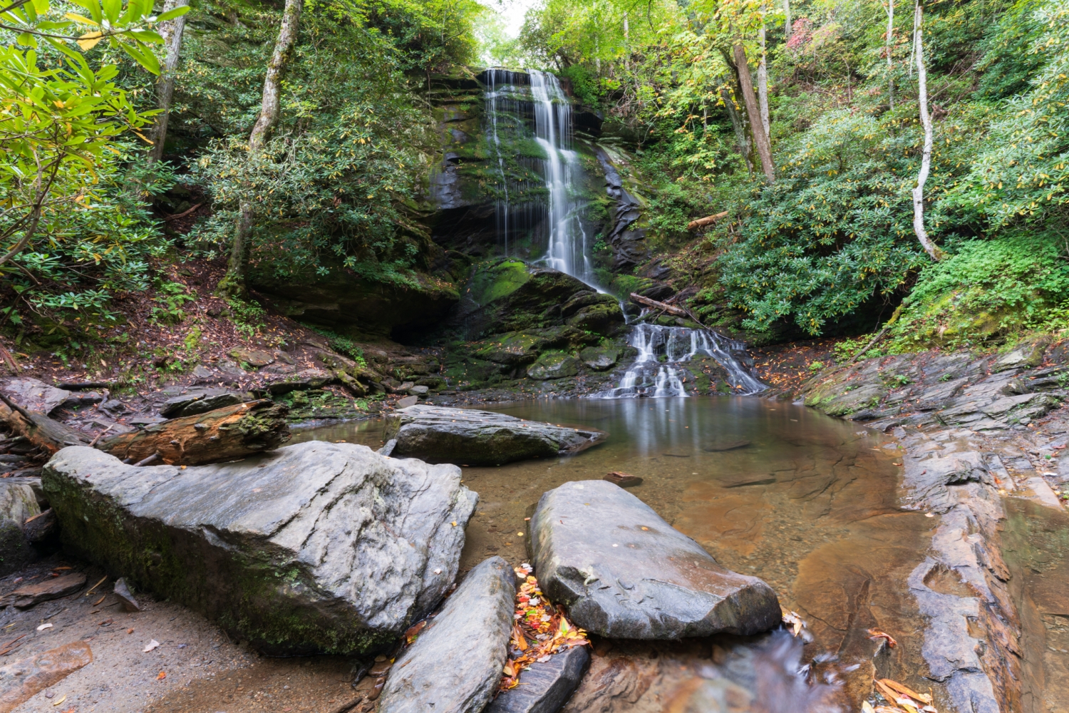
Catawba Falls Trail — Old Fort, NC
Distance: 2.3 miles round trip (lower falls); 3.5-mile loop with Ridge Trail | Difficulty: Easy to Moderate | Dogs: Yes, on leash | Drive from Asheville: About 30 minutes
If you’ve been looking for a waterfall hike that delivers for the whole group — kids, dogs, beginners, and experienced hikers alike — Catawba Falls is it. Located just east of Asheville near Old Fort, this trail follows the Catawba River through a shady, forested valley to a spectacular 205-foot cascading lower falls.
The trail reopened in 2024 after a two-year construction closure, and it’s significantly upgraded. New boardwalks, a 60-foot observation tower, and 580 stairs now take hikers safely to the 80-foot upper falls. If the stairs sound daunting, just hike to the lower falls and back — it’s an easy 1.1 miles one way and worth every step. Looking for a longer adventure? The Catawba Ridge Trail creates a 3.5-mile loop back to the parking lot.
A heads up for dog owners: the metal grate stairs leading to the upper falls aren’t easy for most dogs to navigate. If you’re hiking with your pup, stick to the River Trail to the lower falls and back — still a fantastic outing. Also note that some post-Hurricane Helene repairs are ongoing at the site; check the USFS website before your visit for any current closures.
Spring rainfall makes this one especially rewarding. The falls run at full force, the mist keeps things cool, and the moss on the rock face turns an almost impossible shade of green. Parking is at the end of Catawba River Road off Exit 73 on I-40 — the lot fills fast on weekends, so arrive early.
Best for: Families, beginners, dog owners, waterfall chasers. One of the most accessible great hikes near Asheville.
John Rock Trail Loop — Pisgah National Forest, near Brevard, NC
Distance: 4.8-mile loop | Difficulty: Moderate | Dogs: Yes, on leash (use caution at the exposed summit) | Drive from Asheville: About 40 minutes
Most people visiting Pisgah head straight to Looking Glass Rock — and end up in a long parking line to prove it. John Rock, its quieter neighbor, sits just down the road and offers the same sweeping views of the Davidson River valley with a fraction of the crowd. If you’ve got a moderate fitness level and a full morning to spare, this loop delivers.
The trailhead sits at the Pisgah Center for Wildlife Education (fish hatchery) parking lot off Highway 276. You’ll start on the orange-blazed Cat Gap Loop Trail, crossing a footbridge over the Davidson River and climbing through hardwood forest. Spring hikers are in for a treat: the cove forest along the Cat Gap Loop is one of the best wildflower areas in Pisgah, with trillium, wild geranium, and spring beauties lining the path in April and early May. Listen for Cedar Rock Falls about a mile in — a short side trail drops down to it.
At the 1.2-mile mark, you’ll turn right onto the yellow-blazed John Rock Trail. The climb gets steeper through rhododendron, then opens onto the broad granite summit at 3,209 feet. The view across the valley to Looking Glass Rock is outstanding, and the open rock face makes a perfect lunch spot.
A word of caution: John Rock’s summit is unfenced granite with sheer drop-offs on the edges. Keep your dog leashed, and kids close.
The trail continues from the summit back to the Cat Gap Loop and descends to the Davidson River, completing the loop. The whole thing takes about 2.5 to 3 hours at a comfortable pace.
Best for: Hikers with some trail experience, wildflower enthusiasts, dog owners looking for a challenge, anyone who wants Looking Glass views without the Looking Glass crowds.
Strawberry Gap Trail — Gerton, NC
Distance: 5.1 miles round trip | Difficulty: Moderate | Dogs: No — trail passes through private land; no dogs permitted | Drive from Asheville: About 25 minutes
This is one of the most underrated hikes near Asheville, and it’s practically in the backyard. Strawberry Gap sits just off Highway 74A in Gerton, on the Eastern Continental Divide between Asheville and the Hickory Nut Gorge. The trail climbs 1,200 feet through boulder-strewn forest and rhododendron thickets to a grassy summit bald at 3,760 feet called Blue Ridge Pastures.
The payoff is genuinely spectacular. About 1.5 miles in, you’ll hit Ferguson Peak — a rocky outcrop with sweeping westward views toward Fairview and Asheville, with the Great Smoky and Plott Balsam Mountains in the distance on a clear day. Push on another 1.5 miles to Blue Ridge Pastures for panoramic views looking straight down the Hickory Nut Gorge, with Bearwallow Mountain and Little Pisgah Mountain in the foreground and the Black and Craggy Mountains behind you.
The trail passes through private land protected by conservation easement, which is why there’s one firm rule: no dogs, no exceptions. Leave your pup at River Row this time. The trail is well-maintained with log steps on steeper sections, and the large gravel parking lot off 74A makes access easy.
Spring is an excellent time to hike Strawberry Gap — rhododendron starts blooming along the trail in late April and May, and the views are clear before full summer foliage fills in. This one is managed by Conserving Carolina; follow trail rules and stay on the marked path.
Best for: Solo hikers, couples, and groups without dogs. Ideal for anyone who wants a real climb and a panoramic summit payoff close to Asheville.
Big Bradley Falls Lower Trail — Green River Gameland, Saluda, NC
Distance: 4.0 miles round trip | Difficulty: Moderate | Dogs: Yes, on leash | Drive from Asheville: About 45 minutes
Big Bradley Falls is a 75-foot waterfall tucked into a narrow gorge on Cove Creek in the Green River Gameland near Saluda. The falls are genuinely impressive — powerful, moody, and a little wild — and in spring, when the creek runs high from recent rain, they’re extraordinary.
The Lower Trail approach — accessible from a parking area on Green River Cove Road — follows an old forest road and trail along Cove Creek for about two miles to the falls. The trail passes through beautiful, dense hardwood forest, with wildflowers dotting the forest floor in spring. There’s a creek crossing, so expect to get your feet wet; water shoes or waterproof boots are worth wearing. The views of the surrounding hills and forest along the way make the walk there as enjoyable as the destination.
A critical note on safety:
Big Bradley Falls can be a dangerous area. People have died here, primarily from attempting to access the base of the falls from above via the old Holbert Cove Road overlook trail, which requires a rope descent down a cliff. That approach is not recommended. The Lower Trail route described here is the safer option and does not involve cliff climbing. Still, use good judgment near the falls — the rocks are slippery, and climbing up and around the falls is not recommended.
This trail is off the beaten path and sees lighter traffic than many Pisgah area hikes, which makes it ideal for hikers who want the experience without the crowds. The Green River Gameland is also managed for hunting — check seasonal regulations before your visit and wear blaze orange during hunting season.
Best for: Experienced hikers, adventurous families, waterfall seekers looking for something off the typical tourist circuit, and dog owners who want a longer adventure.
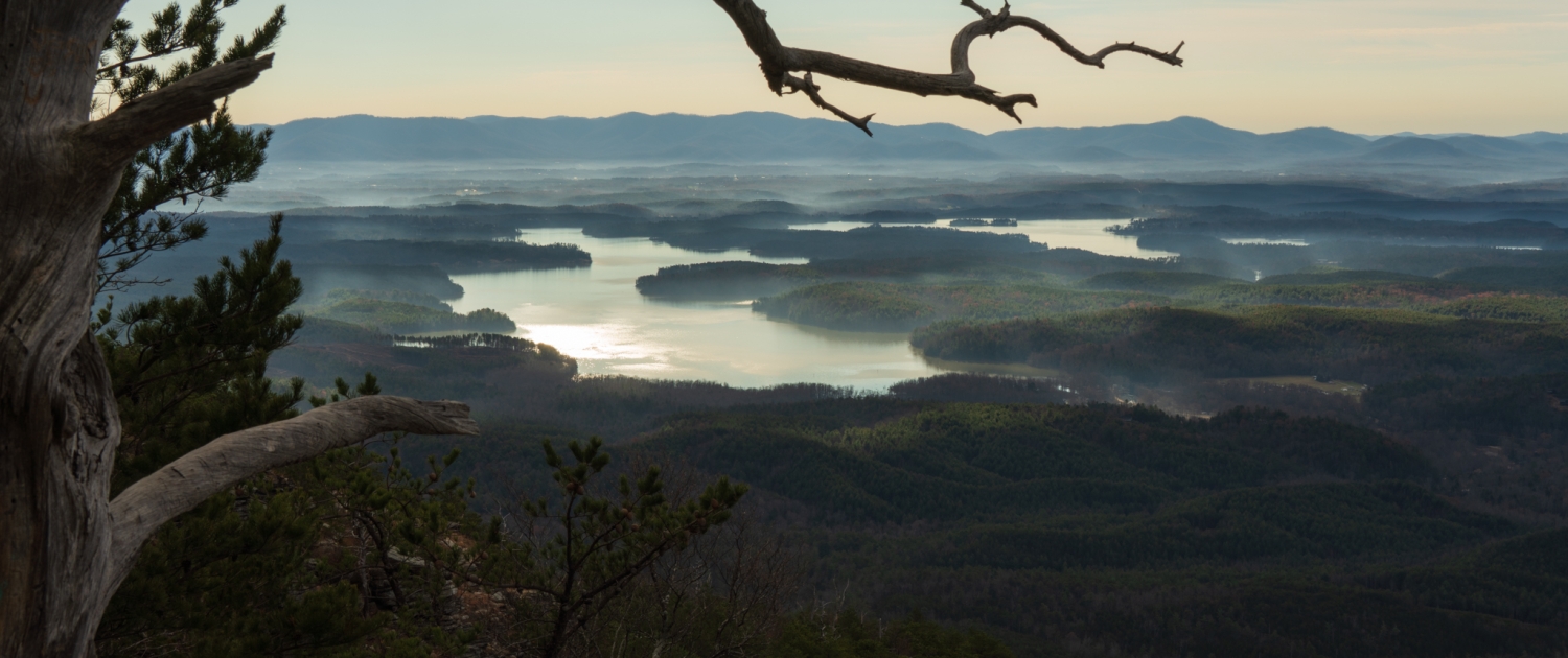
photo credit: Tanya Triber
Shortoff Mountain Trail — Linville Gorge Wilderness, Nebo, NC
Distance: 4.5 miles round trip | Difficulty: Challenging | Dogs: Yes, on leash | Drive from Asheville: About 55 minutes
If you’ve hiked most of the “easy wins” near Asheville and you’re ready for something that earns its views, Shortoff Mountain is calling your name. Located in the Linville Gorge Wilderness — often called the Grand Canyon of the East — this 4.5-mile out-and-back climbs 1,200 feet to the rim of one of the wildest gorges in the eastern United States.
The first mile is the work. You’ll climb steadily on a rocky trail with switchbacks, with views of Lake James opening up behind you as you gain elevation. Two wildfires in 2002 and 2007 cleared much of the tree cover on the lower slopes, which means the views start almost immediately — and also means this section heats up fast in summer. Spring is the ideal season: temperatures are cooler, mountain laurel and rhododendron bloom along the upper trail, and the lack of full foliage means even wider views than you’d get in August.
Once you reach the plateau, the trail levels and becomes one of the more rewarding ridgeline walks in WNC. Rocky outcrops with 360-degree views of Linville Gorge, Lake James, and the distant peaks of Table Rock and Hawksbill appear around every bend. There’s a natural pond near the summit — a rare sight on a mountaintop — and a final set of outcrops that overlook Table Rock make a perfect turnaround point and picnic spot.
The trailhead is at the end of Wolf Pit Road near Nebo (accessible without the Blue Ridge Parkway via I-40). Parking is limited, so arrive early on weekends. Note that weekend and holiday camping permits are required from May 1 through October 31.
Best for: Fit hikers ready for a real challenge, photographers, ridge-walking enthusiasts, and anyone who wants an uncrowded look at one of WNC’s most dramatic landscapes. Dogs are welcome on leash.
Before You Hit the Trail: A Few Spring Essentials
Spring hiking in WNC is spectacular, but the mountains operate on their own schedule. Here’s what to know before you go:
- Check trail conditions. Hurricane Helene impacted many WNC trails in 2024, and recovery work is ongoing. Before your visit, check the USFS website and the relevant land manager sites for current conditions and any remaining closures. Pisgah Ranger District trails are generally open, though some roads have storm damage.
- Dress in layers. Spring mornings in the mountains can be in the 40s and warm to the 60s or 70s by afternoon. The temperature difference between the trailhead and the summit can be significant.
- Wear waterproof footwear. Creek crossings, muddy trails, and wet rocks are all part of spring hiking. Trail runners or hiking boots with some waterproofing will serve you much better than sneakers.
- Catch the ephemerals. Spring wildflowers are fleeting. Most bloom between late March and mid-May, with peak timing varying by elevation. Lower elevation trails like Catawba Falls and John Rock peak earlier; higher trails like Shortoff Mountain and Strawberry Gap bloom later into May.
Make River Row Suites Your Spring Basecamp
Western North Carolina has some of the best spring hiking in the country. The wildflowers, the waterfalls, the ridge views — all of it is within an hour of Asheville, and you don’t need to fight summer crowds to experience it.
River Row Suites sits in the heart of the River Arts District, minutes from I-40 and I-26 — your two main arteries for reaching every trail on this list. After a long day on the mountain, come home to a spacious suite with a full kitchen (ideal for refueling after big miles), a king bed, and free parking. Dogs are welcome, too — because the best hiking partner deserves a good night’s rest.
Spring is one of the best times to visit Asheville. The city is buzzing, the trails are at their most beautiful, and you’ll have the mountains largely to yourself before summer crowds arrive. What are you waiting for?
Book your stay at riverrowasheville.com and start planning your spring adventure in Western North Carolina.
")

 Mieke Campbell

 Momento Mori Photography